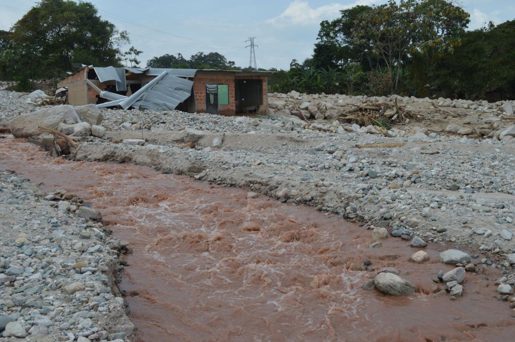
Global scientific cooperation has revealed that a huge rock landslide, rather than a glacial collapse, likely triggered the cascading disaster along the Lhende Khola River.
An international team of scientists has pieced together the sequence of events behind a devastating flood along the Lhende Khola River on the Tibet-Nepal border, concluding that a massive rock landslide was likely the initial trigger rather than a simple collapse of a glacier.
The disaster has killed nearly 600 people, left almost 2,000 missing and destroyed communities, infrastructure and hydropower facilities in the mountainous region. Scientists say the event unfolded as a complex cascade involving a landslide, debris flow and subsequent flooding.
The investigation also demonstrated how rapidly international scientific collaboration and satellite technology can help explain major natural disasters.
Kristen Cook, a geomorphologist at Grenoble Alpes University who has studied the Lhende Khola region, began examining the event shortly after receiving reports of the disaster on 26 August. Initial reports, including information attributed to the U.S. Geological Survey, suggested that a magnitude 4.4 earthquake may have triggered a landslide involving rock and ice.
Cook quickly examined seismic data from a station in Nepal. The signal, however, did not resemble the sharp, short-lived waves normally associated with an earthquake. Instead, it showed prolonged, low-frequency waves characteristic of a large mass movement.
The findings were independently supported by Göran Ekström, a seismologist at Columbia University’s Lamont-Doherty Earth Observatory. Using data from the Global Seismographic Network, which consists of around 200 seismometers operated across the world, Ekström calculated that the seismic event was closer to magnitude 5.7.
The seismic evidence suggested that the ground motion had been generated by an enormous landslide rather than by a conventional earthquake.
The scale of the landslide soon became apparent. Ekström’s calculations indicated that hundreds of millions of tonnes of material would have been required to generate the observed seismic signal, far exceeding the mass contained in the glacier initially suspected of collapsing.
Satellite imagery provided the next critical clues. Scientists shared data through an international group established to investigate the disaster, but early images from Planet Labs were partly obscured by clouds. Nevertheless, the imagery showed a sharp break at around 5,200 metres above sea level, where a glacier appeared to have separated from the mountain.
That observation initially led to speculation that a large section of glacier had collapsed. The fallen ice and rock were believed to have rushed down the valley at speeds approaching 150 kilometres per hour, producing a sudden rise in water levels of as much as nine metres within 30 minutes.
However, researchers found that the glacial-collapse explanation did not fit the available physical evidence.
Scientists studying the cryosphere calculated the amount of energy that would have been released by the collapse and how much ice could have melted as a result. The calculations indicated that the energy would have been insufficient to melt enough ice to account for the enormous volume of floodwater.
At the same time, the seismic signal indicated that a much larger mass of material had moved.
The uncertainty was resolved when cloud-free satellite imagery became available later that day from the Indian Space Research Organisation and Landsat-9, operated jointly by NASA and the USGS. The clearer images revealed the underlying mountain and showed that a huge rock landslide had occurred.
The glacier, researchers concluded, had been carried along with the landslide rather than being the primary cause of the disaster.
The investigation was completed remarkably quickly compared with previous major disasters. Ekström noted that only a few years ago, reaching such a conclusion could have taken months or even years because high-resolution satellite imagery was not readily available.
Scientists working closer to the disaster zone faced a different challenge. Nepal does not operate its own Earth-observation satellites, while heavy cloud cover and difficult terrain limited access to the affected areas. For several hours after the disaster, researchers lacked reliable ground information.
Videos shared on social media provided some early evidence, but drone footage obtained the following day eventually helped confirm the landslide scenario. Researchers estimated that the energy released during the landslide was greater than that of the atomic bomb dropped on Hiroshima.
The event is now being described as a cascading hazard, in which one natural process triggered a series of others. The initial landslide appears to have transformed into a rapidly moving mixture of rock, ice and sediment that travelled down the valley and generated the devastating flood.
A glacial lake outburst flood, or GLOF, was initially considered as another possible explanation. Such an event could occur if debris temporarily blocked the river, creating a natural dam that later failed and released a large volume of water.
However, researchers say seismic and satellite observations have found no convincing evidence of a GLOF.
Instead, the landslide may have incorporated substantial amounts of river water as it travelled downstream. Scientists also suspect that old ice deposits on the valley floor may have been pulverised, melted and mixed into the debris flow, helping explain the unusually large volume of water.
Further field investigations will be necessary to determine exactly how the flood developed. Helicopter surveys, ground investigations, drone observations and interviews with local residents are expected to provide crucial evidence.
Scientists are also investigating whether climate change contributed to the disaster. One possibility is that the gradual thawing of high-altitude permafrost weakened the mountain by reducing the frozen material that binds rock and ice together.
Other researchers are examining whether recent snowmelt allowed water to penetrate fractures in the mountain, potentially destabilising the rock. Changes in glaciers could also have played a role if the ice had been providing structural support to the mountainside.
Landslides are a natural part of the evolution of young mountain ranges such as the Himalayas. However, scientists warn that their frequency and behaviour could change as glaciers retreat and permafrost thaws under a warming climate.
For Nepal and Tibet, the immediate priority remains recovery and rebuilding. The disaster has also renewed attention on early-warning systems capable of detecting rapidly developing cascading hazards and alerting downstream communities.
For scientists who have worked in the region, the disaster has been both a professional challenge and a deeply personal tragedy. The speed with which researchers were able to reconstruct the event demonstrates the growing power of international cooperation, seismic monitoring and satellite observation—but the destruction also highlights the urgent need to translate scientific knowledge into better preparedness for vulnerable Himalayan communities.


 PARYAWARAN
Leave a comment