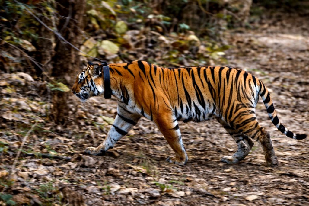
From GPS-enabled patrols and camera traps to drones, DNA analysis and artificial intelligence, technology is giving India’s forest managers new ways to monitor wildlife, prevent conflict and protect threatened species.
At first light, a forest guard once had little more than a notebook, a pair of boots and years of experience to understand what had happened overnight.
A pugmark in the mud could indicate a tiger. Broken branches might reveal an elephant herd. A carcass could point to a predator — or a poacher. The information was valuable, but it was often recorded by hand and could take time to reach the people making decisions.
That forest is still there. The animals are still moving through it.
But increasingly, the forest is also generating a digital trail.
GPS-enabled patrol systems can record where guards have walked. Camera traps can photograph animals without a human observer. Drones can survey difficult terrain. DNA can reveal the presence of elusive species. Satellites can track changes in habitat. And artificial intelligence can increasingly process thousands of images and sounds, helping wildlife managers identify animals and potential threats faster.
The result is not a replacement for field knowledge. It is an expansion of what that knowledge can do.
The forest guard gets a digital map
One of India’s important steps towards technology-assisted wildlife protection has been M-STrIPES — the Monitoring System for Tigers: Intensive Protection and Ecological Status.
Developed through collaboration between the National Tiger Conservation Authority (NTCA) and the Wildlife Institute of India (WII), the system combines GPS, mobile technology, remote sensing, GIS and statistical analysis.
Instead of relying entirely on paper patrol registers, forest personnel can record patrol routes, wildlife sightings, crime scenes and other observations with geographic coordinates. The information can then be analysed to understand patrol coverage, ecological conditions and potential gaps in protection.
That changes something fundamental: the forest is no longer being monitored only as a collection of individual observations, but as a landscape of data.
Camera traps changed the way India counts wildlife
Then came the camera trap.
Triggered by movement, these cameras can operate continuously, capturing animals that may never be seen by a researcher or forest guard. For species with distinctive markings — particularly tigers and leopards — photographs can provide a way to identify individual animals.
The scale of India’s tiger monitoring demonstrates what the technology has made possible.
During the 2018–19 national tiger assessment, camera traps were deployed at 26,838 locations and produced more than 34.8 million wildlife photographs. More than 2,400 individual tigers over one year of age were photo-captured, contributing to the national population estimate.
But millions of photographs create another problem: who has time to examine them all?
That is where artificial intelligence entered the picture.
During the 2018 assessment, AI and neural-network tools were used to automatically segregate camera-trap photographs by species. Software was also used to compare tiger stripe patterns and identify individual animals.
Technology was no longer simply capturing the forest. It was beginning to interpret it.
AI moves from the database into the forest
The next step is potentially more consequential.
Traditional camera traps record an event. Someone later retrieves the images and analyses them.
AI-enabled systems can potentially recognise an event as it happens.
TrailGuard AI, for example, has been deployed in India’s Kanha–Pench landscape. The system uses camera-based detection and communication technology to identify people or wildlife and transmit selected alerts rather than waiting for an entire collection of photographs to be manually reviewed. Researchers have explored its use for both wildlife monitoring and protection from threats such as poaching.
This creates a crucial difference: information can become actionable much faster.
A camera photograph showing a tiger crossing a trail may be useful for research. An alert showing a tiger approaching a settlement can potentially help a forest department warn people before an encounter occurs.
Listening for wildlife
The technological transformation is not limited to images.
In the Pench landscape, an AI-based alert system has been tested using bioacoustics — technology that analyses sounds made by animals. Alarm calls from prey species such as deer can provide clues about the presence of predators.
An AI system can examine these acoustic patterns and help generate alerts when a potential tiger or leopard movement is detected near human settlements.
In March 2026, an AI-based system was reported to be operational in parts of the Nagpur region, with alerts intended for both forest officials and villages near forest areas.
The idea is deceptively simple: instead of waiting for someone to see the animal, let the forest’s own warning system help detect it.
Elephants are getting an early-warning network too
Technology is also being deployed for one of India’s most difficult conservation challenges: human-elephant conflict.
On railway tracks, artificial intelligence and distributed acoustic sensing are being used to detect elephant movement. The system analyses signatures associated with elephant locomotion and can alert railway personnel when elephants are detected near vulnerable stretches.
According to the Ministry of Railways information cited by the government, such an intrusion detection system was operating across 141 route kilometres in critical locations in the Northeast Frontier Railway at the time of the reported update, with installations and sanctioned works planned across several railway zones.
Other early-warning systems use SMS, automated voice calls, sirens and visual signals to alert communities about elephant movement.
Here, technology has a very direct conservation purpose: buying humans and animals enough time to avoid each other.
Drones take conservation into the air
Some landscapes are simply too difficult to monitor from the ground.
Drones can provide aerial views of forests, wetlands, grasslands and difficult terrain. They can help document habitat changes, search for animals and support surveillance operations.
The NTCA has also supported work on using unmanned aerial vehicles for tiger conservation, including surveillance and monitoring and capacity building for frontline staff.
At the Wildlife Institute of India, technology has become an increasingly formal part of conservation research. Its Wildlife Technology Laboratory lists geospatial analysis, remote sensing, drone applications, AI and machine learning, data management and real-time systems among its areas of work.
DNA can find what cameras cannot
Not every animal walks in front of a camera.
Some are rare, elusive or nocturnal. Others may occupy landscapes where visual surveys are difficult.
That is where conservation genetics becomes important.
DNA collected from sources such as animal scat can provide evidence of species presence and, in some cases, help identify individual animals or understand relationships between populations.
The NTCA notes the use of non-invasive genetic sampling of tiger scat in low-density areas to detect tiger presence and estimate the minimum number of individuals.
The approach is also being used at a much larger scale. WII’s recent work includes DNA-based approaches to India’s elephant population assessment.
In other words, conservationists are learning to read not only footprints and photographs, but also the genetic traces animals leave behind.
Satellites are turning conservation into landscape science
Perhaps the biggest change is happening above the forest.
Satellite imagery and GIS allow conservationists to examine forests beyond the boundaries of individual protected areas. Vegetation changes, water bodies, land-use patterns, corridors and fragmentation can be mapped over large areas and monitored over time.
This matters because wildlife does not recognise administrative boundaries.
A tiger may move between a protected reserve and a territorial forest. An elephant herd may cross agricultural land and railway corridors. A leopard may live at the edge of a growing city.
Technology makes it possible to study these movements at the landscape scale — precisely where many conservation problems now occur.
Garuda and the rise of real-time protection
At Nagarahole Tiger Reserve, the Garuda initiative represents another step towards this model.
According to the NTCA’s 2026 STRIPES publication, the pilot combines AI-powered cameras, GSM-enabled camera traps and a central AI engine to support wildlife protection and human-wildlife conflict management. Its objectives include detecting tiger movement near settlements, identifying unauthorised human entry and providing information that can support faster responses.
The significance is bigger than any one system.
Conservation technology is moving from recording what happened to helping predict what may happen next.
But technology is not the answer by itself
There is a danger in viewing technology as a substitute for people.
A camera cannot understand every unusual movement in a forest. An algorithm can make mistakes. A drone cannot replace knowledge of local terrain. A GPS track cannot explain why a patrol officer chose one route over another.
The most effective systems are therefore likely to be those that combine technology with human judgement.
The forest guard remains essential. Local communities remain essential. Researchers, wildlife managers and enforcement personnel remain essential.
Technology is the force multiplier.
It can allow one team to monitor a larger landscape, help managers detect patterns hidden inside enormous datasets and give communities earlier warnings about approaching wildlife.
India’s Wildlife Institute of India now describes technology as an integral part of wildlife research, monitoring and conservation, reflecting how quickly this field is evolving.
From evidence to action
The journey from pugmarks to artificial intelligence is therefore not really about replacing an old technology with a new one.
It is about reducing the distance between what is happening in the forest and what people can do about it.
A pugmark tells a story.
A camera trap records it.
GPS puts it on a map.
DNA can identify what cannot be seen.
Satellite imagery shows the landscape around it.
And AI can increasingly connect thousands of these pieces of information and alert people when something needs attention.
The future of wildlife conservation in India may not belong to technology alone.
It may belong to the combination of boots on the ground, eyes in the sky, cameras in the forest, sensors in the landscape and intelligence in the data.
The animals, meanwhile, continue to follow their ancient routes.
What is changing is our ability to see where they are going — and, increasingly, to act before their paths collide with ours.


 PARYAWARAN
Leave a comment